In your Maximo Spatial projects, things will change. New fire hydrants will be added, new bridges will be built, and new asset types will need to be tracked. Consequently, new layers are added, one may be deleted, and another edited.
Finally, after all that drama, the services were republished, and now your Spatial connection is broken.
What are ESRI Layers?
To start, we’ll talk about ESRI Map Layers. Data collections of geographic data are called layers in ArcGIS. Each layer represents the source data on a Map as points, lines, or shapes, while simultaneously tracking the location of said records. Each layer stores a single type of record, such as a point or line – and data related to each other are grouped together in a single layer. For example, you can have a Map Service representing a city, where a layer storing roads, and a second layer storing bridges. Each layer contains a layer ID which is used within the Map Service URL to directly access the layer via REST API.
What significance do Layer IDs provide to the Spatial configuration?
Whenever a map service is shared, each Layer is a service sublayer and is identified by this unique id, called the layer ID. To access the sublayer, you would use the URL like the following:
https://<service-url>/<layerID>
According to ESRI, in the ArcGIS Pro environment, each layer receives a unique ID that corresponds to its placement within the contents pane, starting with 0 for the initial layer. When you choose to share layers from your map, these IDs are determined by the sequence of the selected layers, which also considers any overarching group layers they may belong to. As you add, remove, or rearrange layers, their IDs will be updated to reflect these changes accordingly
This indicates that Layer IDs could change over time. This creates a problem for our Spatial Configuration, as each Object in Maximo, directly references the services by layer ID. If the Layer ID changes, the Spatial connection WILL break.
How can we avoid this?
There’s two ways to avoid this.
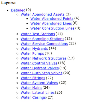
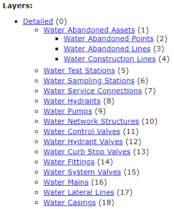
Firstly, is within the ESRI configuration. You can manually assign the layer IDs to ensure they stay static. However, sometimes it is required to change the IDs, because over time, some layers are removed, leaving the appearance of randomly assigned IDs that are in desperate need of reshuffling. See example below of oddly numbered layer IDs over time:

The second way to avoid the breakage, is to cater for these changes within Maximo configuration. Updates aligning Maximo Spatial configuration with GIS, should be periodically planned. In these cases when you need to make the updates to Layer ID, it is important to know the configurations that Maximo needs to be update.
Maximo Spatial utilizes the Layer ID in the following locations:
1. Endpoints2. Map Manager
3. Crontasks
For each service that updated its layer Id, we need to edit their feature objects in these applications. Below serves as a guidance of these updates.
Step 1: Gather new Layer IDs
Use the REST Interface to confirm the Layer Id of the newly published Map Service. Layer ID referenced in Brackets of each layer.

Step 2: Endpoints
For each layer configured, individually change the layer id in the endpoint application:
1. Search for the GISFEATUREOBJECT name2. Update URL in Properties, updating the LayerID to the new value.
Step 3: Map Manager
Update the Map Service URL:
1. Go to the Map Manager application2. Delete the service, then save the record.
3. Re-add the service, and choose the existing GIS Object
Step 4: Crontasks
1. Open ArcGISDataSync Crontask2. For each instance, update URL Parameter to reference the new layerids
After the steps are completed, you will be able to use your Map once again. If you need any assistance, please feel free to reach out to Interloc for assistance.
About Suraj Singh
Suraj Singh is an IBM-awarded Technical Team leader with over 15 years of experience providing Maximo Enterprise Asset Management (EAM) solutions to worldwide clients in the public and private sectors. Suraj uses his expert business and technical system analysis, along with Maximo best practices to provide innovative solutions to his clients in all phases of development, design and implementation. He believes in continuously adapting and embracing evolving technologies and has authored published Geographical Information System (GIS) research articles, Maximo documentation and patents. With his tremendous track record, Suraj is committed to the success of Maximo users across the globe.


